


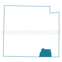
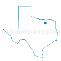
Voting District 0033, Collin County, Texas
About
Outline

Summary
| Unique Area Identifier | 671538 |
| Name | Voting District 0033 |
| County | Collin County |
| State | Texas |
| Area (square miles) | 26.60 |
| Land Area (square miles) | 23.42 |
| Water Area (square miles) | 3.18 |
| % of Land Area | 88.05 |
| % of Water Area | 11.95 |
| Latitude of the Internal Point | 33.00966200 |
| Longtitude of the Internal Point | -96.42861340 |
Maps

Graphs
Select a template below for downloading or customizing gragh for Voting District 0033, Collin County, Texas


Neighbors
Neighoring Voting District (by Name) Neighboring Voting District on the Map
- Voting District 0001, Rockwall County, TX
- Voting District 0008, Collin County, TX
- Voting District 001B, Rockwall County, TX
- Voting District 001C, Rockwall County, TX
- Voting District 0035, Collin County, TX
- Voting District 0042, Collin County, TX
- Voting District 004A, Rockwall County, TX
- Voting District 0083, Collin County, TX
- Voting District 0174, Collin County, TX
Top 10 Neighboring County Subdivision (by Population) Neighboring County Subdivision on the Map
- Plano CCD, Collin County, TX (500,724)
- Northwest Rockwall CCD, Rockwall County, TX (30,185)
- Northeast Rockwall CCD, Rockwall County, TX (18,430)
- Princeton CCD, Collin County, TX (16,255)
- Nevada CCD, Collin County, TX (8,797)
Top 10 Neighboring Place (by Population) Neighboring Place on the Map
- Dallas city, TX (1,197,816)
- Wylie city, TX (41,427)
- Rockwall city, TX (37,490)
- Lavon city, TX (2,219)
- Nevada city, TX (822)
Top 10 Neighboring Unified School District (by Population) Neighboring Unified School District on the Map
- Rockwall Independent School District, TX (63,243)
- Wylie Independent School District, TX (56,745)
- Royse City Independent School District, TX (20,190)
- Princeton Independent School District, TX (14,529)
- Community Independent School District, TX (9,018)
Top 10 Neighboring State Legislative District Lower Chamber (by Population) Neighboring State Legislative District Lower Chamber on the Map
Top 10 Neighboring State Legislative District Upper Chamber (by Population) Neighboring State Legislative District Upper Chamber on the Map
Top 10 Neighboring 111th Congressional District (by Population) Neighboring 111th Congressional District on the Map
Top 10 Neighboring Census Tract (by Population) Neighboring Census Tract on the Map
- Census Tract 313.10, Collin County, TX (9,036)
- Census Tract 404.02, Rockwall County, TX (9,026)
- Census Tract 401.02, Rockwall County, TX (6,716)
- Census Tract 310.01, Collin County, TX (6,635)
- Census Tract 313.08, Collin County, TX (6,358)
- Census Tract 312.01, Collin County, TX (4,787)
- Census Tract 402, Rockwall County, TX (4,430)
- Census Tract 312.02, Collin County, TX (4,010)
Top 10 Neighboring 5-Digit ZIP Code Tabulation Area (by Population) Neighboring 5-Digit ZIP Code Tabulation Area on the Map
- 75098, TX (48,197)
- 75087, TX (28,145)
- 75189, TX (22,406)
- 75407, TX (14,120)
- 75173, TX (4,353)
- 75166, TX (3,070)